Goro Uehara, H. Ikawa, and N. V. Hue
Department of Tropical Plant and Soil Sciences
College of Tropical Agriculture and Human Resources
University of Hawaii at Manoa
Application of Soil Survey and Classification
The purpose of soil classification is to organize what we know
about soils so that this knowledge can be used by farmers, engineers, land
owners, extension agents and government officials to predict the behavior
and performance of soils. A soil, for example, is said to behave like a
sponge if it can hold a large amount of water against the force of gravity.
Such a soil would not need to be irrigated as frequently as a soil that
behaves like a sieve. A wetland taro-farmer wants a soil that can be wetted
and made to behave like a viscous liquid, and an engineer prefers a soil
that can be compacted to behave like an elastic solid. We want to be able
to predict soil behavior because behavior tells us something about soil
performance. We wish to know whether a soil will perform well as a taro
patch, vegetable farm, orchard, road, reservoir, embankment, cemetery or
foundation for a building.
Since there are many different kinds of soil which behave and perform differently,
soil scientists have devised standard procedures to describe, characterize
and name all possible kinds of soil that might occur. Names are useful because
they help us recall the characteristics of an object, whether it be an animal,
plant, person or soil.
Before soils can be named, an inventory of the kinds of soils that occur
in a region must be made. Such an inventory is called a soil survey. The
purpose of a soil survey is to acquire knowledge of the spatial distribution
of the kinds of soils that occur on the landscape. A trained soil surveyor
will draw boundaries around different kinds of soils and produce a soil
map for the region. Since abrupt boundaries between soils are rare, the
surveyor draws a line between two different soils that vary continuously
from one to the other. This immediately tells us that the soils within a
boundary cannot be homogenous and pure. The purity of a soil in map increases
with the intensity or detail of the survey. Where land is expensive a very
high intensity survey may be conducted, whereas in mountainous areas a low
intensity or reconnaissance survey may be more likely.
In a soil survey, a detailed description is kept of each kind of soil that
is mapped. An example of such a description is shown in Table 1. It is evident
from the description that this soil, like most, is naturally organized into
layers called horizons, and that each horizon differs from the one above
and below it. Each horizon is designated by its depth, color, particle
size distribution, structure (the way soil particles are bound together
and arranged in the horizon), consistency (stickiness and plasticity), pore
size distribution, quantity of roots, and other features which the surveyor
considers important to the eventual naming of the soil. Such descriptions
enable soil scientists to see similarities and differences among soils just
as we see them in plants and animals. But unlike plants and animals, the
characteristics of soils that set them apart are not entirely discernible
by eye and must be measured in the laboratory. The laboratory data corresponding
to the soil described in Table 1 are in Table
2. The field description and laboratory data in Tables 1 and 2, along
with a soil survey now make it possible to give names to our soils. As one
would expect, soils that are similar have similar names.
Between 1950 and 1975, soil scientists from the U.S. Department of Agriculture
embarked on plan to develop a comprehensive system for classifying (naming)
soils. Like the Linnean system of classifying plants and animals, this new
system of soil classification is multicategorical or hierarchical. If we
take humans as an example, we are alone as Homo sapiens but belong to the
same groups as chimpanzees at a high category, and to cats and fishes at
yet higher categories. One of the important characteristics of hierarchical
a classification system is that the information about the object being
named increases as one moves down the taxonomic ladder and the objects
themselves
become more alike.
In 1975, the U.S. Department of Agriculture issued a Handbook entitled Soil
Taxonomy (1975). This Handbook provides rules and procedures for classifying
soils on the basis of descriptions and data of the type shown in Tables
1 and 2. Much of the data to classify the soils of Hawaii are contained
in a document entitled "Soil Survey Investigations Report No. 29 --
Soil survey laboratory data and descriptions for some soils of Hawaii"
(1976).
Soil Taxonomy consists of six categories starting with the order at the
highest level, followed by the suborder, great group, subgroup, family and
series as indicated by the example in Table 3.
Series names are for the most part names of places where the soil was first
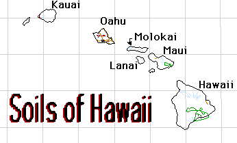
described. Thus the Molokai and Lahaina soil series on Oahu obtained their
names from similar soils first described on Molokai and in Lahaina on Maui.
We even have a soil named after a location in Puerto Rico.
Soil Orders in Hawaii (pictorial view in PDF format).
Table 3. Example of relationships among category subdivisions in soil taxonomy
| Category name | Basis for differentiation |
Example of class name | Main features of the
class |
| Order | Dominant soil process that developed soil | Ultisol |
Clay accumulation: depletion of
bases |
| Suborder | Major control of current processes | Udult |
Soil moist most of time; humid (udic) climate |
| Great group | Additional control | Kandihumult |
Fairly constant soil temp. all year: tropical
environment |
| Subgroup | Blending of processes (integrades) or extra-grades | Typic Kandihumult |
Temporary wetness in rooting zone |
Family | Internal features that influence soil-water-air relationship | clayey oxidic isothermic Typic Kandihumult |
Texture and mineralogy in a control section, and soil temperature |
| Series | Nature of materials that affect homogeneity of composition and morphology | Paaloa |
Soil forming in weathering diabase |
The aim of soil survey and classification is to give identical names to
soils that behave and perform alike. This is to say that a soil in Brazil
which proves to be excellent for producing arabica coffee can also be expected
to do the same for a similarly named kind of soil in Hawaii. It is no accident
that the Molokai and Lahaina soils on Oahu, Molokai and Maui have been used
for nearly identical purposes.
Soils with identical series names should not only look alike but behave
and perform alike. What about soils with identical family names? Can they
be expected to behave alike? It turns out that next to the series, the soil
family is the most practical level for learning from the success and failures
of related soils. If a crop does well on a particular soil, it is very
likely that the crop will also do well on all other soils belonging to that
family. Not only will the crop be expected to perform alike, the management
practices required to achieve a specified level of performance should also
be nearly alike. This method of exchanging soil management information among
closely related soils is called technology transfer by analogy.
Although all 11 soil orders are present in Hawaii, some are more dominant than the others. Their detailed desriptions are listed below (click on the soil order that you want to see)
Table 4. All 11 soil orders are present in Hawaii.
How to use the Soil Survey Reports
The soils of Hawaii have been mapped and classified twice. Field work
for the first survey was completed before World War II, but was not released until 1955 (Cline,
1955). In that report soils were classified according to the now obsolete Great Soil
Group system. In 1975 the U.S. Department of Agriculture issued a Handbook
entitled "Soil Taxonomy," (Staff, USDA, 1975). Hawaii was the first state in the Union to
complete its soil survey based on Soil Taxonomy. The soil survey report appeared in
two parts, one for the Island of Hawaii (Sato et.al., 1972) and the other for Kauai,
Oahu, Maui, Molokai and Lanai (Foote et.al., 1972). The fact that our soil survey reports
predate Soil Taxonomy stems from the wide distribution of draft copies of Soil
Taxonomy, and the long delay in its publication. The delays were caused by last
minute efforts to improve the classification system before sending it to the publisher.
Since its publication, Soil Taxonomy has undergone numerous modifications which
are still on-going.
To use the soil survey, the following steps are required:
1. Identify the Island and select the appropriate Soil Survey Report.
2. Identify the soil's location on the Index to Map Sheets. There is an Index
map for each
island, and each map sheet is numbered.
3. Locate the map sheet (aerial photograph) and pinpoint the site of
interest. The point
will fall in a bounded area (mapping unit) designated with a map symbol.
4. Each soil survey report contains a soil legend which relates the map
symbol to a soil
name. For example, the map symbol LaE3 refers to the Lahaina silty clay, 25 to 40
percent slopes, severely eroded. The letter La stands for the Lahaina series, E for the
slope class and 3 for the erosion class.
5. The full name of the soil series in question is also listed in the report. In
the Soil
Survey report for Kauai, Oahu, Maui, Molokai and Lanai, the Lahaina series is
classified as a clayey, kaolinitic, isohyperthermic, Typic Torrox, which differs from the
current classification. This diffrence reflects the change in name as more knowledge
about the behavior and performance of these soils is gained.
The soil survey report provides a brief description of each soil, including
the
environmental setting in which the soil is found, and other soils that are often
associated with it.
The most useful parts of the soil survey report are the tables which relate
"soil names"
and map symbols to land use suitability for agricultural and non-agricultural uses. The
report, for example, specifies whether the Lahaina soil is suitable for use as top soil,
road fill, highway location, farm ponds, foundations for low buildings, septic tank fields,
and many more. Soil survey reports are especially useful when land use changes at a
rapid pace. Its aim is to enable land owners and policy makers to make the best and
highest use of land.
|