Summary
Mākaha Valley
Invasive Species
Remote Sensing Basics
Model
Model Results
Map
Vegetation Map Results
Derived Map Results
Links
Acknowledgments
References
|
Vegetation mapping results continued
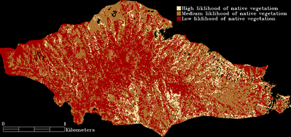
Based on the map and field work, we analyzed the degree to which the map classes were invaded by nonnative species. We regrouped the map classes based on the density of invasive species found within each class:
Classes with the strongest reflectance were extremely dense stands of monotypic invasive alien plants; trees with very large, dense, spreading crowns; or trees with reflective leaf surfaces (kukui). These areas are red in the image below.
Classes with moderate reflectance consisted of moderately spaced, tall invasive trees. These classes often had scattered native species in the overstory or had an understory with a low to moderate amount of native species. These areas are brown in the image below.
Classes with the lowest reflectance had the most native trees in the overstory and/or understory. These areas are cream-colored in the map below. If you would like to see native Hawaiian plants, these regions would be a good place to start.
Click for a higher resolution version of this derived map. |
|
|
University of Hawai‘i at Mānoa. Last updated 2009-03. Contact email: tomoakim@hawaii.edu |